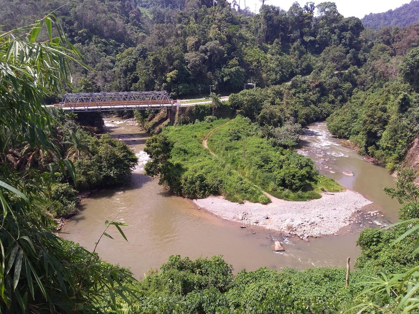
Batang Merangin River Fossil Route Fossil Hunting Guide
Image: Danil Satria (CC0)
Early Permian plant fossils in the bed and banks of a Sumatran river, seen from a rafting route of about 13.8 kilometres. The Jambi flora of the Mengkarang Formation is dated to roughly 296 million years and is described as the last exposed assemblage of its kind.
By Edward Chen · Published 12 September 2026
Introduction
Most fossil sites are walked. This one is floated. The Early Permian plant fossils of the Mengkarang Formation lie in the bed and banks of the Batang Merangin in Sumatra. The practical way to see them is a rafting route of about 13.8 kilometres that takes roughly three hours.
The fossils are known collectively as the Jambi flora, and the geopark describes them as the last exposed assemblage of their kind in the world. That claim rests on palaeogeography. These plants grew on Cathaysialand, a set of equatorial continental fragments distinct from Gondwana to the south and Angaraland to the north. Exposures of that flora are now rare.
The dating is unusually precise for a site of this kind. Isotopic work on the volcanic rocks interbedded with the fossil beds brackets the Mengkarang Formation between 296.77 and 296.14 million years. That places it in the Asselian, the first stage of the Permian.
UNESCO designated Merangin Jambi a Global Geopark in 2023.
Location and Directions
The fossil route runs along the Batang Merangin in Merangin Regency, Jambi Province, in central Sumatra.
GPS: 2.1734°S, 102.1250°E.
Bangko is the regency town and the usual base. Jambi city has the nearest airport, with a long road journey inland from there.
Access is by booked river trip. Operators run the rafting route. Do not attempt it independently, both for safety and because the guides know where the fossil outcrops are.
The drier months, roughly June to September, are the practical window. Outside it the river runs high and fast, which makes the trip unsafe and submerges the outcrops the route exists to show.
What Fossils You'll Find
Nothing is collectable. The geosites are protected within a UNESCO Global Geopark.
Silicified wood is the most visible element. Araucarioxylon and Agathoxylon are the named genera, both conifer woods, and trunks occur in the riverbed and banks.
Leaf and stem impressions make up the rest of the flora, and the assemblage is what gives the geopark its scientific standing.
Marine fossils occur alongside the plants, which is the interesting part. Brachiopods, crinoids and fusulines have been described from the formation, so the sequence records both land vegetation and shallow sea.
 Photo: Roby diery, CC BY-SA 4.0, via Wikimedia Commons

Geologic History
The Mengkarang Formation is Lower Permian, Asselian, around 296 million years old. It consists of eight intervals of volcanic tuff and volcaniclastic sediment that fine and thin upward, overlain by reworked alluvial material.
That composition is the key to the preservation. Volcanic ash is rich in silica, it buries material quickly, and it supplies the silica that replaces wood cell by cell. The same mechanism operates at Lesvos and at Khorixas, and it is the standard recipe for a fossil forest.
The setting was a volcanic island arc or continental margin on Cathaysialand, in the equatorial tropics. The mixture of marine and terrestrial fossils reflects a coastal environment where rivers met a shallow sea.
Those Cathaysian fragments later travelled and were assembled into what is now south-east Asia. That is why a flora of this affinity is found in Sumatra at all.
Cathaysialand is worth a note. In the Permian the world's land was largely assembled into Pangaea. But a set of equatorial fragments carried their own distinct flora, adapted to a wet tropical climate while Gondwana to the south was glaciated. The Jambi flora is a window onto that separate botanical world.
 Photo: Roby diery, CC BY-SA 4.0, via Wikimedia Commons

Collecting Rules and Regulations
Collecting is prohibited. The fossil localities are protected geosites within the geopark, and Indonesian law protects geological heritage.
Do not take wood fragments from the riverbed, however loose they appear.
Photograph what the guides show you. Report anything unusual to the geopark information centre.
Silicified wood preserves structure that charcoal and compression fossils destroy. Growth rings, cell walls and vessel arrangement survive, which lets researchers identify the plant group and read the climate it grew in from ring width. That is why the Jambi wood carries more information than its appearance suggests.
Safety
This is a river trip, and the river is the hazard. Wear the buoyancy aid and helmet provided and follow the guide's instructions.
Do not attempt the route outside the dry season or without an operator.
Rocks in and beside the river are slippery, and the current is strong even at low water.
Sumatra is tropical, hot and humid. Sun exposure on open water is severe.
Mosquito-borne disease is a risk in lowland Sumatra, so use repellent and take advice on malaria prophylaxis before you travel.
The precision of the dating deserves emphasis. Isotopic ages with uncertainties measured in tens of thousands of years, on a rock roughly 296 million years old, are exceptional. It is possible here because volcanic material is interbedded directly with the fossil beds, which is rarely the case at plant localities.
Sources
https://www.unesco.org/en/iggp/merangin-jambi-unesco-global-geopark https://scholarworks.boisestate.edu/geo_facpubs/440/ http://geopark.meranginkab.go.id/en/halaman/detail/geotourism https://www.researchgate.net/publication/259159061_Brachiopods_fusulines_and_palynomorphs_of_the_Mengkarang_Formation_Early_Permian_Sumatra_and_their_palaeobiogeographical_significance
Nearby sites
 Sangiran Early Man Site Fossil Hunting GuideHominins, Mammals
 Porcupine Gorge National Park Fossils Fossil Hunting GuideGlossopteris, Glossopteris leaves
 Maria Island Fossil Cliffs Fossil Hunting Guidebrachiopod shells, bryozoans
 Karoo National Park Fossil Trail Fossil Hunting GuideDicynodonts (Aulacephalodon, Oudenodon), Gorgonopsids (Rubidgea)