
Miguasha National Park Fossil Guide
Image: Everything Everywhere Travel (Used with attribution)
Miguasha National Park on the Gaspé Peninsula of Quebec preserves the world's best-known Late Devonian "Age of Fishes" fossil Lagerstätte, 370-million-year-old cliffs that record the evolutionary transition from sarcopterygian fish to the first four-legged tetrapods. UNESCO World Heritage. Visitors walk the in-situ cliffs with a guide and tour the on-site museum.
By Edward Chen · Published 30 May 2026
Miguasha National Park is a small (87-hectare) provincial park on the south shore of the Gaspé Peninsula in eastern Quebec, fronting the Bay of Chaleur. Its sea cliffs expose the Late Devonian (Frasnian, roughly 380–370 million years ago) Escuminac Formation, which preserves a freshwater-to-marginal-marine community of fishes and early tetrapod-relatives in notable detail. Since the cliffs were first recognised by Abraham Gesner in 1842, more than 18,000 specimens have been collected, and Miguasha was inscribed as a UNESCO World Heritage Site in 1999, the only Devonian fossil site on the World Heritage List.
The park is managed by Société des établissements de plein air du Québec (SÉPAQ). Visitors pay a modest park entry fee to access the on-site Miguasha Natural History Museum (which displays more than 9,000 specimens, including the lobe-finned fish Eusthenopteron foordi and the elpistostegalian Elpistostege watsoni, currently the closest known fish-relative of tetrapods) and to walk a guided cliff-base path along the in-situ exposures during the open season.
This guide covers what you'll see, how to reach the park, and the rules that protect one of paleontology's best-known fish-to-tetrapod transition sites.
Location and Directions
Miguasha is on the south shore of the Gaspé Peninsula in eastern Quebec, near the village of Nouvelle.
Directions to Miguasha National Park
The park entrance is at 231 Route Miguasha O, Nouvelle, Quebec, about 50 km west of Carleton-sur-Mer and 250 km east of Rimouski. Most visitors approach via Route 132 along the Gaspé coast. The park has signed turn-offs from Route 132 at Nouvelle.
The park is open daily from early June to mid-October. Outside the season the cliffs are accessible from the shoreline but the museum and guided programs are closed. Park admission includes museum entry and a short ranger-led walk to the cliff base, where visitors can see in-situ fossiliferous shales and watch the active research excavation (in season). A longer interpretive trail loops through the upper park.
The museum café is small. Pack a lunch. Carleton-sur-Mer is the nearest sizeable town for lodging and supplies.
What Fossils You'll See
The Escuminac Formation was deposited about 380 to 370 million years ago, during the Frasnian Stage of the Late Devonian, in a brackish coastal estuary along the southern margin of Laurussia (the assembled Late Devonian supercontinent of Laurentia plus Baltica) that was periodically connected to the open Devonian Rheic Ocean. The setting was warm, humid, near-equatorial, and biologically unusually productive.
The museum and the in-situ cliff walk feature the full Miguasha vertebrate community at the centre of which sit the sarcopterygians, the lobe-finned fish that gave rise to all terrestrial vertebrates including humans. The most famous Miguasha sarcopterygian is Eusthenopteron foordi, a 1- to 1.5-metre-long predator with paired bone-cored fleshy fins, a single dorsal lung, and skull bones that match, element by element, those of the earliest tetrapods. Eusthenopteron has been the textbook "tetrapod ancestor" for more than a century and is the single most-illustrated fossil fish in vertebrate-evolution textbooks worldwide. Holoptychius jarviki is a much larger sarcopterygian known from massive scales and the occasional partial skeleton. The recently named Elpistostege watsoni, described in detail in 2020 from a complete Miguasha specimen recovered in 2010, is an elpistostegalian that preserves articulated finger-like bones (homologues of digits) within its pectoral fin and is currently considered the closest known fish-relative of true tetrapods. The first detailed digit anatomy preserved in any sarcopterygian comes from this Miguasha skeleton.
The placoderms, heavily armoured jawed fish that dominate the Miguasha biomass, are represented by Bothriolepis canadensis, by far the most abundant species at the site. Bothriolepis is a small box-shaped antiarch with paired armoured arm-like pectoral appendages, and is so common at Miguasha that complete specimens are recovered every few weeks during the summer collecting season. The larger arthrodire placoderm Plourdosteus canadensis and the small Antiarchi species Asterolepis round out the placoderm fauna. The acanthodians, small, slender "spiny sharks" with paired fin spines, include Diplacanthus, Triazeugacanthus, Gyracanthides, and Homalacanthus. Many are preserved as complete bodies with both scales and spines articulated.
The agnathans, the jawless fish that were diversifying at Miguasha's time before being out-competed by jawed fish, include the heterostracan Endeiolepis aichmetia, the anaspid Euphanerops longaevus (whose unusual long body has made it a focus of recent functional-anatomy research), and several smaller taxa. Primitive chondrichthyans (sharks and their relatives) are present but rare. Plant fossils are surprisingly common given that the depositional setting is brackish: large axial fragments of the progymnosperm tree Archaeopteris hibernica (one of the earliest known true trees) and the enormous filiform fungus or fungal-like organism Prototaxites loganii both occur, along with smaller bryophyte and early vascular plant fragments. Trace fossils, burrows, fin trails, and bite marks on fish bone, round out the assemblage.
Eighteen thousand specimens have been collected from Miguasha since fieldwork began in earnest in the 1870s, making this the most intensively sampled single Devonian fossil locality in the world.
"It is the only Devonian site on the World Heritage List... the largest number and the best-preserved fossil specimens in the world of sarcopterygian fish, which gave rise to the first four-legged, air-breathing terrestrial vertebrates, the tetrapods." UNESCO
Geologic History
The Escuminac Formation accumulated in an estuarine to brackish-bay setting at the mouth of a large river system draining the southern flank of the Caledonian / Acadian mountains, which had been built up during the Mid-Devonian Acadian orogeny when the Avalon micro-continent collided with Laurussia. The setting was warm, monsoonal, and equatorial, with abundant freshwater input from inland and periodic marine incursions through tidal channels that connected the bay to the open Rheic Ocean.
Fine, dark, organic-rich mudstones interbedded with thin siltstone storm layers accumulated on the bay floor. The mudstones contain abundant fish remains preserved as carbonaceous compressions with bone-and-scale detail intact. Mass-mortality layers within the section, recognisable as bone beds containing thousands of articulated Bothriolepis and other taxa, record episodes of mass mortality probably tied to seasonal salinity or oxygen changes, fresh water draining off the mountains during monsoonal seasons, salt water inundating during dry intervals, that periodically wiped out the local fish community. Rapid burial in the soft anoxic mud preserved articulated skeletons with fine fidelity, often with skin outlines and gut contents intact.
The deposit was uplifted, deeply buried, and tilted gently during the late Paleozoic Alleghanian phase of Appalachian orogenesis. Pleistocene glacial erosion stripped overlying Carboniferous and Permian cover from the Gaspé region, exposing the Devonian rocks at the modern surface. Present-day marine erosion of the Bay of Chaleur cliff line, driven by storm waves, freeze-thaw cycles, and frost wedging, retreats the cliffs at a few centimetres per year on average. Continued cliff retreat continuously refreshes the fossil exposures, exposing new bone surfaces each year, and SÉPAQ park paleontologists monitor the cliffs and recover newly exposed material each summer before it is lost to the bay.
The Miguasha cliffs were first noted by the Acadian residents of the Gaspé in the early 19th century, with collecting beginning in earnest after Sir Robert Schomburgk and Sir Charles Lyell's notices brought the site to international attention in the 1840s. Major late-19th-century work by John Whiteaves of the Geological Survey of Canada, Erik Stensiö of the Swedish Natural History Museum in the early 20th century, and the long-running Université Laval and SÉPAQ project from the 1980s onward have together produced the modern Miguasha collection.
How Miguasha Came to Be a National Park
The site was acquired and developed as a Quebec provincial park (parc national, in Quebec's official terminology) in 1985 to protect the cliff section and to support continuing research. SÉPAQ, the Société des établissements de plein air du Québec, has administered the park since the early 1990s. The on-site Miguasha Natural History Museum opened in 1993, and UNESCO inscribed the park as a World Heritage Site in 1999 (Site #686) under criterion (viii) as the world's most outstanding illustration of the Devonian Period.
Collecting Rules & Regulations
Is Fossil Collecting Allowed?
No. Collection is prohibited throughout the park and along the beach below the cliffs.
Key Points:
- Park entry fee required during open season (early June–mid October)
- No collection, hammering, or removal of any fossil or rock
- Stay on marked trails and the guided cliff-base path
- Photography permitted. Commercial filming requires SÉPAQ permission
- Notable exposed finds should be reported to park staff
- The cliffs are tidal. Consult tide tables for the beach walk
Sources
Nearby sites
 Joggins Fossil Cliffs Fossil Hunting GuideLycopsid trees, Plant fossils
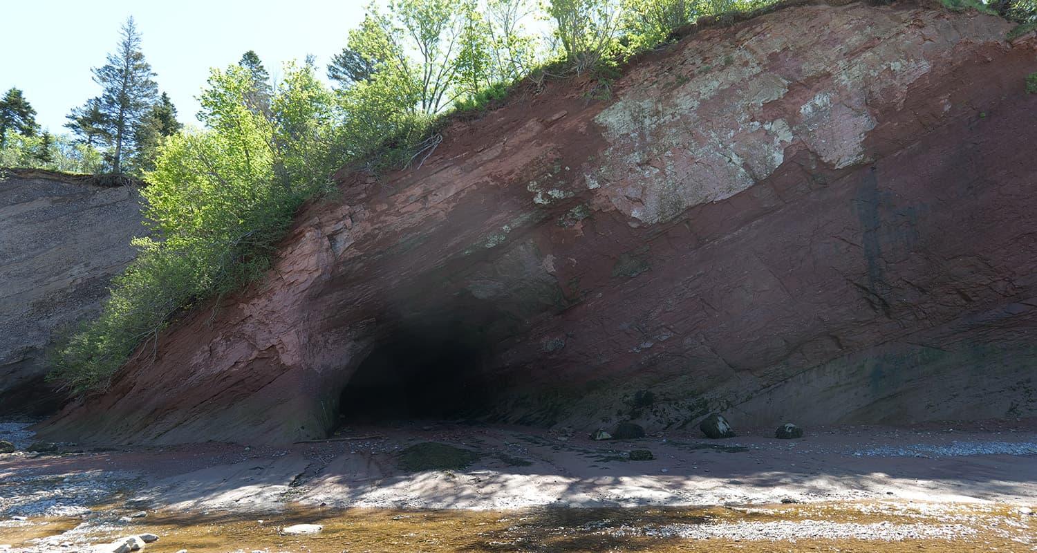 Stonehammer UNESCO Global Geopark Fossil Hunting GuideParadoxides regina (trilobite), Carboniferous tetrapod trackways
 Mistaken Point Ecological Reserve Fossil Hunting GuideFractofusus, Charnia
 Rock Glen Conservation Area Fossil GuideBrachiopods, Horn corals