Mistaken Point Ecological Reserve Fossil Hunting Guide
Mistaken Point Ecological Reserve on the southeast tip of the Avalon Peninsula in Newfoundland preserves more than 10,000 Ediacaran body fossils on a single bedding plane dated to about 565 million years ago. Access is by booked guided tour only. No collecting is permitted.
By Edward Chen · Published 4 June 2026
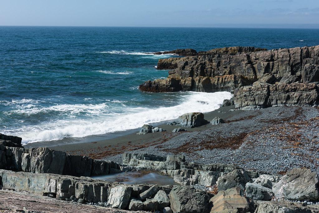
Mistaken Point Ecological Reserve protects 5.7 kilometres of coastal cliff and platform on the southeast tip of the Avalon Peninsula in Newfoundland. The reserve preserves a sequence of late Ediacaran sandstone, siltstone, and volcanic ash beds in the Mistaken Point Formation of the Conception Group, exposed in continuous outcrop along the sea cliffs between Portugal Cove South and Cape Race. Several individual surfaces in this section are dusted with the bodies of soft-bodied frond-like organisms that lived in deep water around 565 million years ago and were buried under volcanic ash from offshore eruptions. The result is more than 10,000 catalogued body fossils preserved as casts on a series of bedding planes. The site holds the oldest known assemblage of large, complex multicellular life on Earth. Mistaken Point was inscribed on the UNESCO World Heritage list in 2016 and is managed by the Province of Newfoundland and Labrador as a strict-protection ecological reserve. Visitor access to the fossil surfaces is only by a guided tour, booked through the reserve. Collecting is prohibited. This guide covers the booking process, what the tour shows, the deep-water Ediacaran geology, and the rules that apply.
Location and Directions
The reserve sits at the southeast tip of the island of Newfoundland, about 145 kilometres south of the city of St. John's. From St. John's, take Highway 10 (the Irish Loop) south through Witless Bay and Trepassey, then continue to Portugal Cove South. The drive is about two and a half hours.
The Edge of Avalon Interpretation Centre at Portugal Cove South is the booking office and tour meeting point. The address is Edge of Avalon Interpretation Centre, Portugal Cove South, Newfoundland and Labrador A0A 3K0. GPS is 46.6660 degrees north, 53.2230 degrees west.
The tour itself starts at a small parking area south of Portugal Cove South, off the Cape Race lighthouse road. From the parking area, the group walks roughly 3.5 kilometres on a marked gravel track and rocky coastal slope to reach the main fossil surface. The walk takes about 45 minutes one way over uneven ground. The complete round-trip experience runs about 3 to 4 hours.
Tours run daily from mid-May through mid-October, weather permitting. There are typically morning and afternoon departures during peak summer months. Group size is capped at about 15 visitors per tour. Booking in advance through the reserve interpreters is required and can be arranged by phone at +1 709 438 1011 or by email at mistakenpointtour@gov.nl.ca. The tour is free of charge at the time of writing, but pre-booking is mandatory.
The closest commercial airport is St. John's International Airport. Fuel, lodging, and meals are available in Trepassey, about 25 kilometres back along Highway 10.
What Fossils You'll Find
You will not collect at Mistaken Point. What you can do is walk a few centimetres above the original sea floor of an Ediacaran abyss and look down on the bodies of organisms that have no clear living relative. Identifications below are drawn from the UNESCO nomination file and the published scientific literature on the reserve.
- Fractofusus. A self-similar branching organism reaching about 30 cm long, abundant on several bedding planes. Population studies on Fractofusus at Mistaken Point provide the earliest known evidence of clonal reproduction in animals.
- Charnia masoni. A frond-shaped rangeomorph that was the first Ediacaran macrofossil ever recognised, originally described from Charnwood Forest in England in 1958. Mistaken Point preserves some of the best-preserved Charnia specimens in the world.
- Charniodiscus. A holdfast-anchored frond up to 50 cm tall, common on the main surface.
- Bradgatia. A bush-shaped rangeomorph with multiple radiating branches, present in moderate numbers.
- Thectardis. A triangular, hollow organism, possibly an early sponge.
- Pectinifrons. A comb-shaped rangeomorph attached to the sea floor by a holdfast.
Trace fossils interpreted as drag marks of attached fronds are present on several surfaces. The reserve also contains the Ediacaran sponge-grade fossil Haootia quadriformis, described in 2014 as a possible early cnidarian.
The principal fossil surface, known as the E surface, contains more than 4,000 specimens visible on a single exposed slab.
Geologic History
The fossils sit in the Mistaken Point Formation of the Conception Group, deposited in a deep marine basin on the Avalonian microcontinent in the late Ediacaran. Radiometric ages on volcanic ash beds within the section constrain the principal fossiliferous surfaces to between 574 and 560 million years ago, with the famous E surface dated to about 565 million years ago.
The basin in which the organisms lived was below the photic zone, well below storm wave base, at water depths estimated between 750 metres and 2 kilometres. There was no photosynthesis at this depth. The Ediacaran fronds appear to have lived by absorbing dissolved organic matter from sea water through their finely subdivided fractal surfaces.
The exquisite preservation of body outlines, fine surface texture, and internal branching at Mistaken Point is the result of rapid burial under thin pyroclastic ash falls. Volcanic ash from offshore island-arc eruptions settled onto the sea floor and entombed the soft-bodied organisms before they could decay. The base of each ash bed preserves a faithful cast of the buried community. Some of the higher fossil surfaces at Mistaken Point preserve organisms in their original life orientation, with holdfasts on the bedding plane and fronds standing up into the ash.
After deposition, the Avalonian sequence was rotated to the south during Pan-African and Acadian tectonic events, then transported to its modern position by post-Pangean spreading. The bedding planes at Mistaken Point now dip steeply seaward but expose the original upper surfaces.
How Mistaken Point Became a Fossil Site
S.B. Misra, a graduate student from Memorial University of Newfoundland, identified the first frond fossils on a coastal traverse in 1967 and described them in a 1969 Nature paper. Through the 1980s and 1990s, work by Guy Narbonne, Mike Anderson, and Paul Myrow at Queen's University, Memorial University, and Colorado College mapped the surfaces in detail and produced the first systematic species list. The 1996 declaration of the Mistaken Point Ecological Reserve protected 5.7 kilometres of coast.
The reserve was inscribed on the UNESCO World Heritage list in July 2016 under cultural criterion (viii), recognising its outstanding universal value for the history of life on Earth. Research collection continues under permit from the Department of Environment, Climate Change and Municipalities.
Collecting Rules and Regulations
Collecting is strictly prohibited. Mistaken Point Ecological Reserve is a category Ia strict-protection area under the Newfoundland Wilderness and Ecological Reserves Act. Removing or damaging any fossil, rock, or organism in the reserve is an offence under provincial law.
Practical rules:
- Access to the fossil surfaces is by booked guided tour only. Independent visits to the surfaces are not allowed.
- Touching the fossil surfaces is permitted only with bare clean feet, after the interpreter removes the rope barrier. Shoes are removed at the edge of the bedding plane to prevent abrasion damage.
- Photography for personal use is welcomed everywhere on the tour.
- Drones are not permitted in the reserve.
- Pets are not allowed on the guided tour.
- Bring rain gear and warm layers regardless of season.
Safety
Newfoundland coastal weather changes quickly. Fog, wind, and rain are common even in July and August. Carry waterproof outer layers, warm mid layers, and sturdy hiking boots with good ankle support.
The walk to the fossil surface crosses uneven rocky ground with no shelter. Mobility limitations should be discussed at booking time. The reserve provides interpreters but does not provide accessibility infrastructure on the trail.
Stay close to the interpreter throughout the tour. The coastal cliffs above the fossil surface drop steeply to the Atlantic and are subject to rogue waves. Do not approach the cliff edge.
Cell coverage is intermittent. Carry a printed copy of the booking confirmation and the meeting point directions.
Sources
- UNESCO World Heritage Centre, "Mistaken Point." https://whc.unesco.org/en/list/1497/
- Government of Newfoundland and Labrador, "Mistaken Point Ecological Reserve." https://www.gov.nl.ca/eccc/natural-areas/wer/r-mpe/
- Mistaken Point Ambassadors, "Mistaken Point UNESCO World Heritage Site." https://mistakenpoint.ca/
- Narbonne, G.M., 2005. "The Ediacara Biota: Neoproterozoic Origin of Animals and Their Ecosystems." Annual Review of Earth and Planetary Sciences, 33.
- Liu, A.G., McIlroy, D., and Brasier, M.D., 2010. "First Evidence for Locomotion in the Ediacara Biota from the 565 Ma Mistaken Point Formation." Geology, 38.
Nearby sites
 Joggins Fossil Cliffs Fossil Hunting GuideLycopsid trees, Plant fossils
 Miguasha National Park Fossil GuideSarcopterygian fish, Placoderms
 Stonehammer UNESCO Global Geopark Fossil Hunting GuideParadoxides regina (trilobite), Carboniferous tetrapod trackways
 Rock Glen Conservation Area Fossil GuideBrachiopods, Horn corals