Stonehammer UNESCO Global Geopark Fossil Hunting Guide
Stonehammer UNESCO Global Geopark covers 2,500 square kilometres around Saint John, New Brunswick, the first UNESCO Global Geopark in North America. The park's 60+ geosites trace a billion-year rock record from Precambrian stromatolites through Cambrian trilobites and Carboniferous tetrapod trackways.
By Edward Chen · Published 4 June 2026
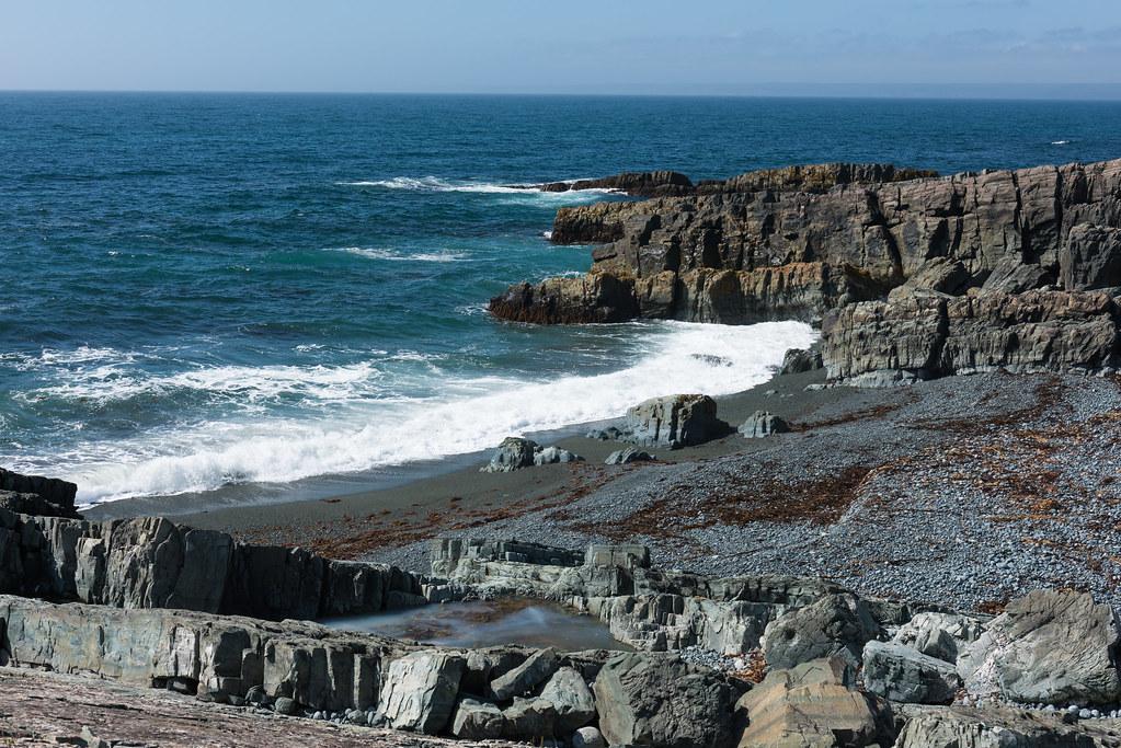
Stonehammer UNESCO Global Geopark covers about 2,500 square kilometres of southern New Brunswick, centred on the city of Saint John and extending east toward the Kennebecasis River, north along the Bay of Fundy, and west to St. Martins. The geopark was designated by UNESCO in 2010, becoming the first UNESCO Global Geopark in North America. The geology preserved within the park covers nearly a billion years of Earth history, from late Precambrian stromatolites in the Green Head Group through Cambrian and Ordovician marine sediments of the Saint John Group, Silurian and Devonian rocks of the Mascarene basin, and Carboniferous coastal-plain and reef sediments along the Bay of Fundy. The combination of rock units exposed in a single accessible region is unusual. More than 60 individual geosites have been documented, and at least a dozen are open to the public with formal interpretation, including the Saint John Reversing Falls Skywalk, the Fossil Centre on the campus of the New Brunswick Museum, the Cape Spencer headland, and several outcrops along the Fundy Trail Parkway. The Cambrian Saint John Group has produced the trilobite Paradoxides regina, one of the largest known trilobites. The Carboniferous Albert Formation contains some of the world's earliest tetrapod trackways, and the late Carboniferous Salisbury Cove section preserves standing lycopsid trees similar to those at Joggins, Nova Scotia. Collecting is prohibited at protected geosites. This guide covers how to plan a circuit, what each main stop shows, the geological history, and the access rules.
Location and Directions
Saint John sits on the Bay of Fundy in southern New Brunswick, about 100 kilometres east of the Maine state line and 350 kilometres east of Bangor. The closest commercial airport is Saint John Airport (YSJ). Halifax and Boston are the main onward commercial hubs, both about four to six hours away by car or air.
Discover Saint John, at 47 Charlotte Street in the city centre, is the visitor information hub for the geopark. GPS is 45.2733 degrees north, 66.0633 degrees west.
Several signed driving routes link the main geosites. A typical circuit starts at the New Brunswick Museum on Douglas Avenue, continues to the Reversing Falls Skywalk, then to Cape Spencer headland, the Stonehammer beach circuit at Saints Rest, and ends at the Fundy Trail Parkway and St. Martins sea caves.
The Fundy Trail Parkway charges an entry fee per vehicle. Most other geosites are free, with paid admission only at the New Brunswick Museum and at some private commercial stops.
The recommended visiting window is May through October. The Fundy Trail Parkway is closed in winter. Saint John itself is open year round but receives heavy snow and reduced services from December through March.
Saint John has full lodging, dining, and fuel. Several smaller communities along the Bay of Fundy provide accommodation closer to the outlying geosites.
What Fossils You'll Find
You will not collect at Stonehammer's protected geosites. What you can do is visit the New Brunswick Museum Fossil Centre, walk to in-place outcrops at signed geosites, and read on-site panels that explain each stop. Identifications follow the Stonehammer geopark interpretation panels and published work by Randall Miller, Greg Edgecombe, and Howard Falcon-Lang.
- Paradoxides regina. A large Middle Cambrian trilobite, sometimes exceeding 50 centimetres in length, from the Hanford Brook Formation of the Saint John Group. The species is among the largest trilobites known.
- Carboniferous tetrapod trackways. Tetrapod prints from the Mississippian Albert Formation, including some of the oldest documented tetrapod trace fossils in eastern North America.
- Precambrian stromatolites. Some of the finest preserved stromatolites in the world come from the Green Head Group, exposed along the Kennebecasis River and on outcrops near Saint John.
- Silurian eurypterids. Sea scorpion fragments and rare complete specimens from the Mascarene Group.
- Devonian armoured fish. Placoderm material from the Campbellton Formation north of Saint John.
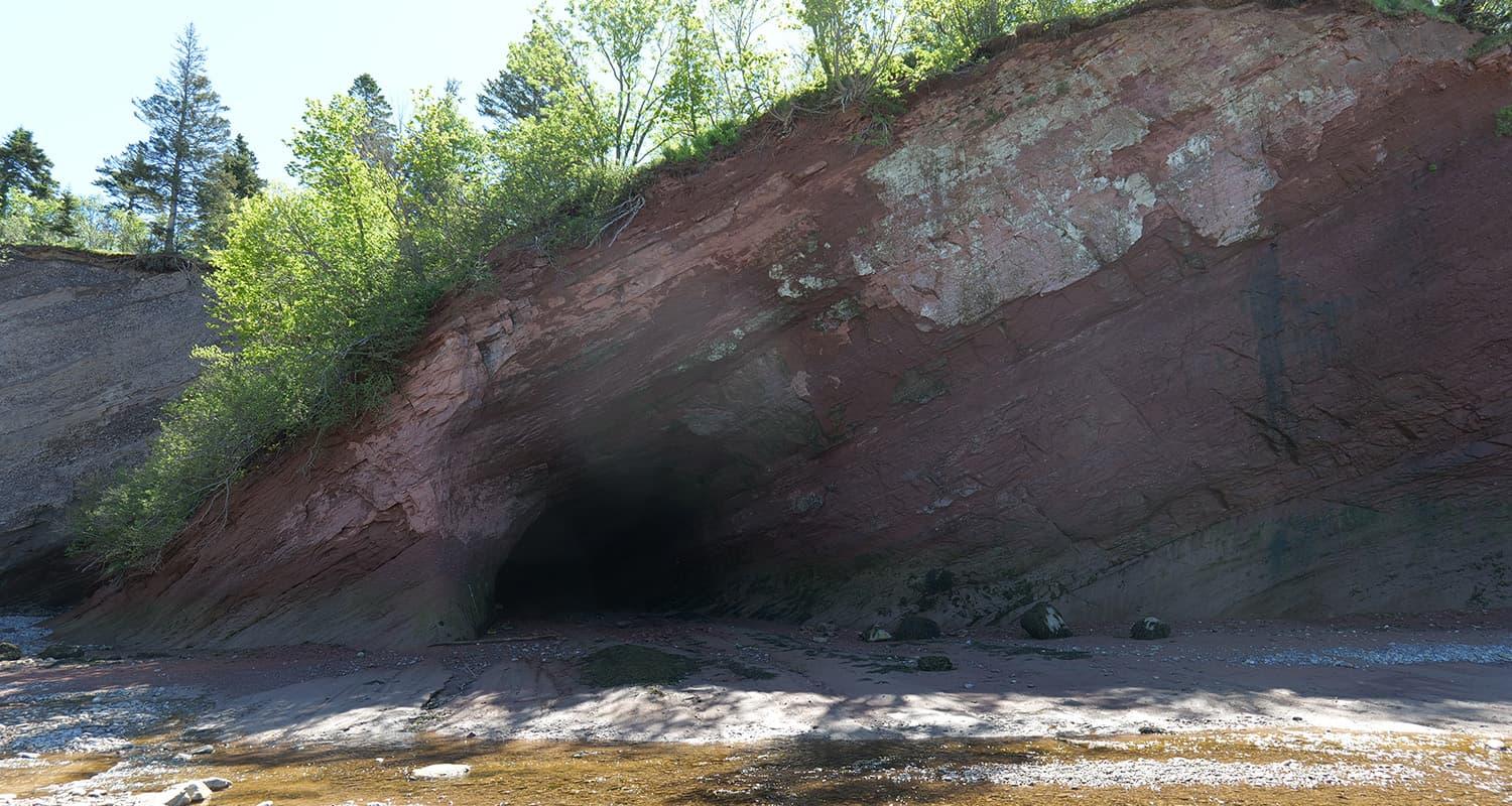
- Late Carboniferous lycopsid trees. Standing tree trunks preserved in growth position on Pennsylvanian coastal-plain rocks at Salisbury Cove, similar to those at Joggins.
- Insects and giant arthropods. Late Carboniferous insect impressions and large arthropleurid millipede traces.
The New Brunswick Museum holds the principal mounted and prepared collection from across the geopark. The museum runs scheduled guided fossil-handling sessions during the summer.
Geologic History
The Stonehammer area sits at the eastern edge of the Appalachian orogen and exposes rocks from at least four major tectonic settings stacked together by Paleozoic plate collisions. The principal periods recorded in the geopark:
The Precambrian Green Head Group, late Mesoproterozoic in age at roughly 1.0 billion years old, contains marble and dolomitic stromatolite reefs deposited on a Grenville-age carbonate platform. Saint John quarried this marble in the nineteenth century for building stone.
The Cambrian to Ordovician Saint John Group, roughly 540 to 480 million years old, contains shale and sandstone deposited on the Avalonian continental margin in deep marine settings. The large trilobite Paradoxides regina comes from this group.
The Silurian Mascarene Group, roughly 430 to 420 million years old, contains volcanic and sedimentary rocks deposited during the Acadian Orogeny. Eurypterids and early fish appear in this section.
The Mississippian Albert Formation, roughly 350 to 330 million years old, contains lake and floodplain sediments deposited in the Maritimes basin. Early tetrapod trackways come from these rocks.
The Pennsylvanian rocks along the Bay of Fundy, roughly 320 to 300 million years old, contain coal-bearing coastal-plain sediments with the standing lycopsid trees of Salisbury Cove.
The Mesozoic record at Stonehammer is more limited but includes Triassic red beds along the Bay of Fundy that overlie the Carboniferous section.
After Carboniferous deposition, Appalachian compression folded and uplifted the older sequences. Erosion through the Mesozoic and Cenozoic exposed the productive horizons in coastal cliffs and inland river cuts.
How Stonehammer Became a Fossil Site
Geological mapping of the Saint John area began in the early nineteenth century, and the New Brunswick Museum, founded in 1842 as the first natural history museum in Canada, has held collections from the region since its earliest years. Charles Frederic Hartt and George F. Matthew published the first systematic monographs on Saint John Group fossils in the 1860s and 1870s. Matthew described Paradoxides regina in 1888 and established the Saint John Group's biostratigraphy.
The Stonehammer UNESCO Global Geopark was inaugurated in 2010 after a coordinated regional campaign led by the New Brunswick Museum, the City of Saint John, and the regional tourism authority. The geopark designation recognises the regional density of accessible geosites, the strong educational and tourism infrastructure, and the active research programmes at the New Brunswick Museum and at the University of New Brunswick. Research collection continues across the region under New Brunswick provincial paleontological permits.
Collecting Rules and Regulations
Collecting is prohibited at the protected geosites. The New Brunswick Heritage Conservation Act protects designated paleontological resources, and the Stonehammer geosites are listed under this regime. Some unprotected outcrops on Crown land may allow casual fossil collection under provincial Crown Land rules. The geopark visitor centre can advise on which sites are accessible and which are off limits.
Practical rules:
- Stay on marked paths and viewing zones at signed geosites. Climbing on in-place trackway or trunk exposures is not allowed.
- Photography for personal use is welcomed at all sites.
- Most geosites are free to visit. The New Brunswick Museum, Reversing Falls Skywalk, and Fundy Trail Parkway charge admission.
- Drones require advance permission from the geopark office and from any private landowner if the geosite sits on private land.
- Pets must be leashed and are not permitted inside indoor exhibits.
- Research collection is restricted to permitted teams working under New Brunswick provincial authorisation.
Safety
Coastal Bay of Fundy weather changes quickly. Fog, rain, and wind are common even in July and August. Carry waterproof outer layers and warm mid layers on every outdoor visit.
The Bay of Fundy has the highest tides in the world, with vertical ranges of more than 12 metres at Saint John. Some coastal geosites are accessible only at low tide. Check local tide tables and the Stonehammer geopark visitor information before walking out to a coastal stop.
Coastal cliffs around the Bay of Fundy are unstable in places. Stay back from cliff edges. Loose rock falls without warning, especially after rain.
The interior parts of the geopark have moose, black bear, and tick populations. Carry tick repellent in the warm months.
Cell coverage is reliable in Saint John and intermittent along the Fundy Trail Parkway and some outlying geosites. Carry a printed Stonehammer geopark map.
Sources
- Stonehammer UNESCO Global Geopark, "Our Geology." https://stonehammergeopark.com/our-geology/
- UNESCO Global Geoparks Network, "Stonehammer." http://www.globalgeopark.org/GeoparkMap/geoparks/Canada/12511.htm
- Miller, R.F., 2012. "Stonehammer Geopark, New Brunswick, Canada." Geology Today, 28. https://onlinelibrary.wiley.com/doi/10.1111/j.1365-2451.2012.00838.x
- Falcon-Lang, H.J. et al., 2006. "Pennsylvanian forests preserved in growth position at the Joggins Fossil Cliffs, Nova Scotia." Geology, 34.
- New Brunswick Museum, "Fossils of New Brunswick." Visitor information accessed June 2026.