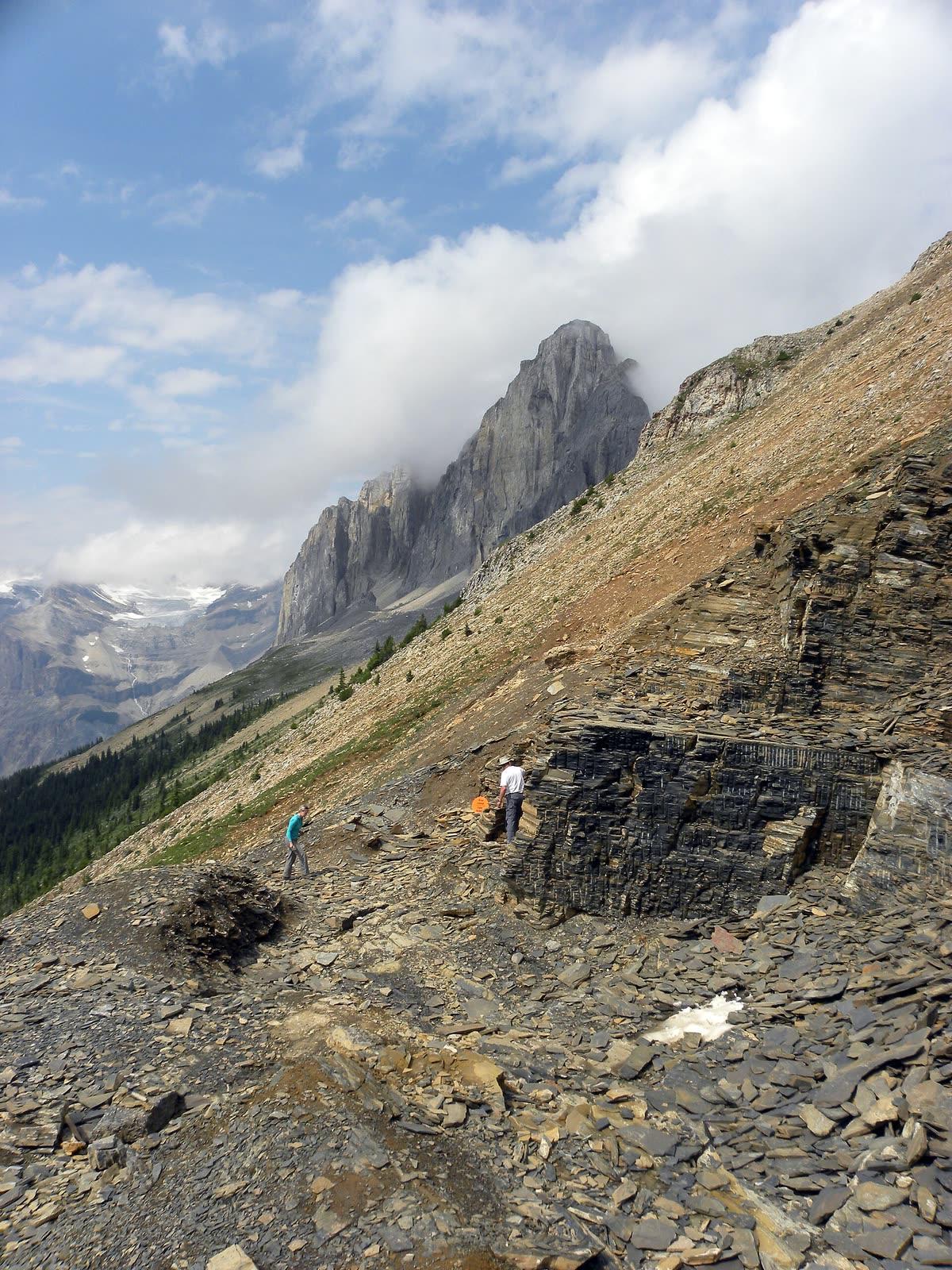
Burgess Shale Fossil Hike Guide
Image: Mark A. Wilson (Public domain)
The Burgess Shale in Yoho National Park preserves one of the world's best-known Cambrian fossil assemblages, over 200 species of soft-bodied marine animals from 508 million years ago. The Walcott Quarry and Mt. Stephen trilobite beds are closed to the public and may only be visited on Parks Canada guided hikes.
By Edward Chen · Updated 31 July 2026
Introduction
The Burgess Shale is one of the world's most well-studied fossil sites and a UNESCO World Heritage Site within Yoho National Park, British Columbia. It records an notable snapshot of marine life from the Cambrian Explosion 508 million years ago, including the soft tissues, eyes, gills and gut contents of animals normally lost to decay.
The two main fossil quarries, the Walcott Quarry on the ridge between Mount Field and Mount Wapta, and the Mt. Stephen Trilobite Beds above the village of Field, are closed to the general public and protected under the Canada National Parks Act. Access is permitted only via guided hikes operated by Parks Canada or the licensed Burgess Shale Geoscience Foundation, or with a research permit. Reservations for the 2026 hiking season open January 20, 2026 at 8:00 am MST and fill quickly.
This guide covers what you'll see, how to reach the site, and the rules governing one of paleontology's most famous localities.
Location and Directions
The Burgess Shale sits high on the slopes above Field, BC, inside Yoho National Park about 200 km west of Calgary along the Trans-Canada Highway.
Directions to the Burgess Shale
Trailheads for all guided hikes start in or near Field, BC. The Walcott Quarry hike begins at the Takakkaw Falls parking area in the Yoho Valley. The Mt. Stephen Trilobite Beds hike begins from the south side of Field. A valid Parks Canada national park pass is required for every participant and must be purchased the day before, as gates and visitor centres are closed in the early morning when hikes depart.
The Walcott Quarry hike is roughly 22 km round trip with 825 m of elevation gain and takes about 11 hours. The Mt. Stephen hike is shorter (about 8 km) but steeper. Children under 8 are not permitted on the Walcott hike, and those 9–16 must be accompanied by an adult.
 Photo: Chris Woodrich, CC BY-SA 4.0, via Wikimedia Commons
What Fossils You'll See
The Burgess Shale fossil assemblage represents a deep-water Cambrian marine community preserved in notable detail by rapid burial in fine sediment slurries from above. Together the various Burgess Shale localities have produced more than 200 species spanning a quarter-billion-cell-volume snapshot of mid-Cambrian life, including soft-bodied animals that left no other record in the Phanerozoic.
Visitors on the Walcott Quarry hike see the original quarry walls excavated by Charles Walcott beginning in 1909, with thousands of fossils still visible weathering out of the talus below the bench. The trilobite Olenoides serratus is the easiest fossil to recognise, small, ovoid, with three lobes and clear pleural ridges, and turns up in many of the slabs the guides point out. The "lace crab" Marrella splendens is the single most abundant Burgess Shale animal, with delicate paired carapace spines and a body about 2 centimetres long. Tens of thousands have been recovered from this site alone. The metre-long apex predator Anomalocaris canadensis is well represented by isolated frontal grasping appendages and the occasional disc-like oral cone, with a few partial bodies preserved on the bench. The bizarre five-eyed proboscis-bearing Opabinia regalis and the spiny worm Hallucigenia sparsa (now interpreted as a primitive velvet-worm relative) both occur in the same beds. Most famously, Pikaia gracilens, a small leaf-shaped chordate about 4 centimetres long, is the earliest accepted member of our own phylum and a possible ancestor of vertebrates.
The Burgess Shale also preserves a wide range of more conventional fauna: brachiopods (Acrothyra, Nisusia), sponges (Vauxia, Pirania, the dish-shaped Eiffelia), early molluscs (Wiwaxia), the early echinoderm Echmatocrinus, the iconic predatory worm Ottoia prolifica often found with its last meal (typically a Wiwaxia) preserved in its gut, the swimming arthropod Sidneyia, the giant carnivorous arthropod Sanctacaris, and the colonial pterobranch hemichordate Oesia. Around 17% of the recovered fauna remain difficult to assign to any known phylum.
On the Mt. Stephen hike, the older Stephen Formation trilobite beds expose dense slabs of Ogygopsis klotzi and the larger predator Olenoides serratus in such abundance that loose blocks of fossiliferous limestone litter the slope. Smaller and rarer Mt. Stephen taxa include the soft-bodied predator Anomalocaris, the bivalved arthropod Tuzoia, and a number of agnostid and ptychopariid trilobites.
"These sites are protected under the National Parks Act and may only be visited on scheduled guided hikes or with a research permit." Parks Canada
 Photo: James St. John, CC BY 2.0, via Wikimedia Commons
Geologic History
The Burgess Shale formed during the middle Cambrian (Wuliuan Stage, about 508 million years ago) at the foot of a massive submarine carbonate cliff called the Cathedral Escarpment. North America at the time was at the equator and the proto-Pacific margin of Laurentia was a tropical, shelf-and-slope carbonate platform. The Cathedral Escarpment marked the abrupt seaward edge of this platform, dropping more than 150 metres into deeper, oxygen-poor mud. Burgess Shale organisms lived on, around, and below the foot of this submarine cliff in a narrow band where the sea floor was unstable.
Periodic underwater mud-and-silt slurries, turbidity currents, slid down the slope and entombed entire communities of soft-bodied animals almost instantly. Because the burial was nearly instantaneous and the resulting muds were dysoxic to anoxic, the soft tissue had no time to decay before being sealed. Subsequent diagenetic conversion of the original carbonaceous films to aluminosilicate compressions preserved fine anatomical detail, gills, gut contents, eyes, antennae, even the spent meal of a predator, at a level of fidelity rare in the fossil record. Two-dimensional carbon-film fossils with three-dimensional relief are the typical preservation mode.
The Burgess Shale was uplifted, deformed, and tilted into vertical and overturned attitudes during Late Cretaceous Laramide orogenesis, which built the Canadian Rocky Mountains. The Walcott Quarry exposure now sits on a steep north-facing slope near 2,300 metres elevation, just below treeline. Modern erosion of the bench slowly weathers fresh blocks out of the in-place quarry walls and onto the talus below, where they are accessible to guided hikers but not to anyone else.
Charles Doolittle Walcott of the Smithsonian Institution discovered the Burgess Shale on August 31, 1909, when his pack horse stumbled across a slab of Marrella-bearing shale that had slid down the slope. He worked the quarry that bears his name from 1910 to 1924, recovering more than 65,000 specimens that now form the core of the Smithsonian collection. The Royal Ontario Museum and Cambridge University expeditions of the 1960s through 1990s, led by Desmond Collins and Harry Whittington, opened the new Raymond Quarry just above the Walcott Quarry and reinterpreted the fauna. Whittington and his students Simon Conway Morris and Derek Briggs published a famous series of monographs in the 1970s and 1980s that transformed scientific understanding of the Cambrian Explosion and the early evolution of animal body plans, popularised in Stephen Jay Gould's 1989 book Wonderful Life.
How the Burgess Shale Came to Be Protected
The Walcott Quarry was inscribed as a UNESCO World Heritage Site in 1980 and incorporated into the broader Canadian Rocky Mountain Parks World Heritage Site (Site #304) in 1984. The Royal Ontario Museum continues to hold the active collecting permit, and Parks Canada and the licensed Burgess Shale Geoscience Foundation jointly run the guided hike programme. Strict protection ensures fossils remain in situ for ongoing scientific research while a small number of guided visitors, typically a few thousand a year, can experience the site each summer.
 Photo: James St. John, CC BY 2.0, via Wikimedia Commons
Collecting Rules and Regulations
Is Fossil Collecting Allowed?
No. Collecting, hammering, or removing any fossil or rock from the Burgess Shale is strictly prohibited under federal law. Photography is encouraged.
Key Points:
- Independent hiking to the Walcott Quarry or Mt. Stephen Trilobite Beds is not permitted
- All access requires booking a guided hike in advance
- Touching fossils in place is allowed. Lifting, hammering, or removing is not
- A national park pass is required in addition to the hike fee
Safety
Access to the Burgess Shale localities is by guided hike only, and that restriction exists for conservation reasons rather than safety ones. The hikes themselves are the safety issue, and they are considerably harder than most visitors expect from a fossil trip.
These are strenuous mountain hikes, not walks. The routes climb steeply for several hours to alpine elevations, with substantial elevation gain, and you carry your own food, water, and layers the whole way. Guides set a pace and turn people back who cannot keep it. Be honest with yourself about fitness before booking, and break in your boots beforehand rather than on the trail.
Alpine weather changes fast. Snow is possible in any month at these elevations, and a warm valley morning can become sleet on the ridge. Carry proper waterproof and windproof layers, a warm mid-layer, hat and gloves, and sun protection, since ultraviolet exposure is high and reflects off snow. The season is short, and trips are cancelled for weather.
This is bear country. Both grizzly and black bears live in Yoho, and your guide will brief you on group spacing and noise. Stay with the group, do not lag behind for photographs, and carry no scented items loose in an outer pocket.
Footing on scree and talus is loose and ankles turn easily. Altitude may shorten your breath if you have come from sea level. Bring more water than you think you need, because there is none on the route, and tell the guide early if you are struggling rather than at the point where you cannot continue.

_(Burgess_Shale_Formation,_Middle_Cambrian;_Walcott_Quarry,_above_Field,_British_Columbia,_Canada).jpg)
_(15083634948).jpg)