Lake Texoma (Eisenhower State Park) Fossil Hunting Guide
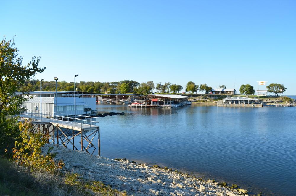
Image: Luis Tamayo from Arlington, Texas, USA, USA (CC BY-SA 2.0)
Lake Texoma straddles the Texas-Oklahoma border on the Red River and exposes Lower Cretaceous Duck Creek and Fort Worth Formation marine shales along its shoreline. Dinner-plate-sized ammonites, irregular echinoids, and oyster clusters are the headline finds. Within Eisenhower State Park (TX), collecting is prohibited under Texas Parks and Wildlife rules. Outside the park, collecting depends on landowner permission.
By Edward Chen · Updated 1 August 2026
Introduction
Lake Texoma is a 89,000-acre reservoir on the Red River that forms the border between north Texas and south-central Oklahoma. The reservoir, impounded by Denison Dam (completed 1944), drowned a section of the Red River valley where Lower Cretaceous marine shales and limestones of the Washita Group crop out at low elevations. Around the lakeshore, particularly within Eisenhower State Park on the Texas side north of Denison, the Duck Creek Formation and overlying Fort Worth Formation produce a classic Lower Cretaceous fauna: dinner-plate-sized ammonites, irregular and regular echinoids, large oysters, and other shallow-marine fossils approximately 100 million years old. Within Eisenhower State Park itself fossil collecting is prohibited under Texas Parks and Wildlife Department rules. Visitors observe and photograph fossils but leave them in place. Outside the park, in the many creeks and bluffs that feed the reservoir, collecting depends on landowner permission and is on private or US Army Corps of Engineers land.
This guide covers the visitor experience at Eisenhower State Park, the Duck Creek Formation fossils, and the property and access landscape around the lake.
 Photo: GrapevineTxOnline.com, CC BY 2.0, via Wikimedia Commons
Location and Directions
Lake Texoma sits about an hour north of Dallas-Fort Worth along US-75 / US-69. Denison Dam, the southern impoundment, is at the southeast corner of the lake. Eisenhower State Park is on the Texas shore just upstream of the dam, in Grayson County. The park address is 50 Park Road 20, Denison, TX 75020. From US-75 take exit 67 west on FM-1310, then north on Park Road 20 to the park entrance. Eisenhower charges a daily Texas Parks and Wildlife entrance fee.
Where to look within the park
Inside the park, the Fossil Ridge area and the trails around the Ammonite Crossing Bridge and Ammonite Scenic Point are the standard places where Cretaceous fossils can be observed in-situ in the limestone bedrock. The scenic point itself is on a rock overlook above the lake where ammonite impressions are visible in the underlying limestone. These features can be photographed and pointed out to children, but the Texas Parks and Wildlife trail-etiquette rule (and state law) is clear: take only photographs.
 Photo: Larry D. Moore, CC BY 4.0, via Wikimedia Commons
What Fossils You'll Find
The bedrock around Lake Texoma is the Lower Cretaceous Washita Group, in particular the Duck Creek Formation (lower, about 105 to 102 million years old, Albian) and the overlying Fort Worth Formation (slightly younger, about 102 to 100 million years old). Both units are alternations of marl, clay, and limestone deposited on the broad shallow-marine shelf that fringed the western interior seaway when it was still narrow and the Texas region lay along its southern margin.
The headline fossils are ammonites. Eopachydiscus and Mortoniceras are the genera most consistently reported from Duck Creek exposures in the Texoma area and along feeder creeks in Cooke and Grayson Counties to the south. Some Eopachydiscus marcianus specimens approach a metre in diameter, large enough that weathered examples lie like pavement stones in the creek beds where they occur. Irregular echinoids are common in some beds, especially the heart urchin Holaster simplex and the lateral-symmetry oddity Hemiaster. The regular echinoid Phymosoma is less abundant but also documented. Oysters are everywhere: Exogyra arietina, Texigryphaea navia, and other thick-shelled forms occur as both isolated valves and dense pavement-like coquinas. Other bivalves include Inoceramus and various scallop-like pectinids. Shark teeth occur in lag deposits, principally Cretolamna, Carcharias, and Squalicorax, although they are far rarer than the invertebrate fossils. Nautiloids and the occasional small turtle bone round out the assemblage.
"Just below Fossil Ridge, you can look for evidence of ammonite fossils near the Ammonite Crossing Bridge near the lake. The Ammonite Scenic Point offers a rock overlook above the lake where fossil beds can be seen below, with spiral-shaped ammonite fossils fused into the surrounding limestone." Texas Parks and Wildlife Department
Geologic History
During the Albian (Lower Cretaceous), the modern Texas region lay on the southern margin of an embryonic Western Interior Seaway, the inland sea that connected the Arctic Ocean with the Gulf of Mexico across central North America for much of the Cretaceous. The Washita Group records that early phase as a series of shallow-shelf carbonates and marls deposited in subtropical to tropical conditions with abundant ammonite and mollusc faunas. The Duck Creek Formation lies near the top of the Comanchean (Lower Cretaceous) succession in north Texas. The Fort Worth Formation immediately overlies it. The whole succession is more famous around Fort Worth, where the same units crop out at the surface and produce many of Texas's classic Cretaceous ammonites and echinoids, but the Lake Texoma exposures are northern equivalents of the same beds.
After the Cretaceous high stand ended, regional uplift and erosion stripped the younger Cretaceous units and exposed the Washita Group at the surface across much of north Texas and southern Oklahoma. Modern weathering and the impoundment of Lake Texoma combined to produce the present exposures: the lake's shoreline cuts across the marls at lake level, and freeze-thaw and wave action keep fresh fossils in supply at the surface.
How Lake Texoma became a fossil destination
The lake itself dates to 1944, when the Denison Dam was completed for flood control and hydroelectric generation on the Red River. The Lower Cretaceous fossils were known to the geologists who mapped the area long before impoundment. Once the lake formed, the new shoreline exposures became popular with amateur paleontologists from the Dallas-Fort Worth and Oklahoma City regions, and the area remains one of the standard north Texas Cretaceous collecting regions today. The state park was established in 1954 and named for President Eisenhower, who was born in Denison.
Collecting Rules & Regulations
Is Fossil Collecting Allowed?
No, not within Eisenhower State Park. Outside the park collecting depends on landowner permission.
Key Points:
- Within Eisenhower State Park, disturbing or removing fossils is prohibited under Texas Parks and Wildlife rules. Photograph only.
- Outside the park, much of the immediate shoreline is US Army Corps of Engineers land managed for the reservoir. Collecting requires Corps permission.
- Private land along feeder creeks (Duck Creek, Mineral Creek, others) sometimes hosts amateur trips with landowner consent.
- Where collecting is permitted outside the park, hand tools only.
- Texas-side ammonites and Oklahoma-side ammonites are from the same formations. Rules differ by jurisdiction.
Safety
Eisenhower State Park is a developed state park, so the hazards are the ordinary ones of a Texas lakeshore in summer.
Heat is the first. Grayson County summers run above 95°F with high humidity, and the Fossil Ridge trails and the Ammonite Scenic Point are exposed limestone with little shade. Walk early or late, carry water, and watch children for the early signs of heat illness.
The Ammonite Scenic Point is a rock overlook above the lake with a drop below it. The limestone is smooth and becomes slippery when wet or dusted with loose grit. Keep back from the edge and hold onto children.
The shoreline moves. Lake Texoma is a Corps of Engineers flood-control reservoir and its level changes by several feet through the year. Exposures that are walkable in late summer are underwater in spring, so do not plan a route along the bank from last year's photographs.
Copperheads occur across the park and cottonmouths near the water. Watch where you step in leaf litter and among rocks. Chiggers and ticks are abundant from spring through autumn, so cover your legs and check yourself afterwards.
Boat traffic close inshore is heavy on summer weekends. If you are walking the waterline, stay visible and out of designated swimming and launching areas.
Sources
- Texas Parks & Wildlife: Eisenhower State Park
- Nautiloid.net: Lake Texoma Duck Creek Formation Cretaceous
- Fossil-Quest: North Texas Cretaceous
- DFW Fossils: Mortoniceras Ammonites of the Duck Creek Formation
- Palaeontological Association: The Cretaceous ammonite Eopachydiscus
- TPW Magazine: Under the Ancient Ocean at Eisenhower State Park