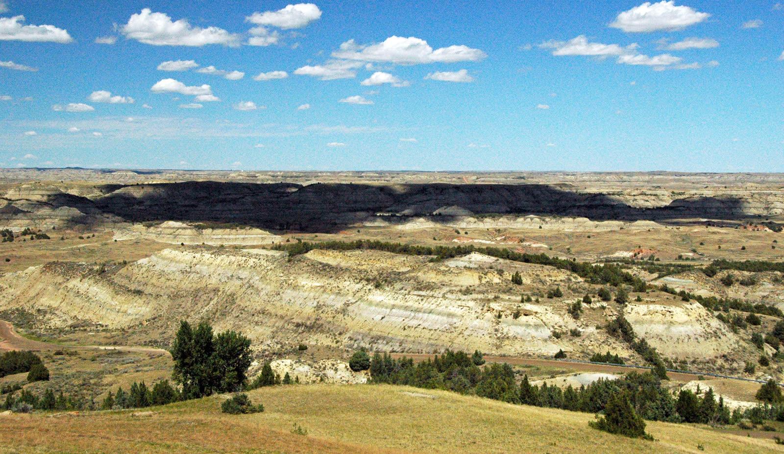
Petrified Forest Plateau, Theodore Roosevelt National Park Fossil Hunting Guide
Image: James St. John (CC BY 2.0)
The Petrified Forest Plateau in the South Unit of Theodore Roosevelt National Park, North Dakota, holds upright fossil tree stumps in the Paleocene Sentinel Butte Formation. It is a backcountry walk of about 1.5 miles from a remote trailhead. The park bans all collecting, so this is a viewing-only site.
By Edward Chen · Published 1 October 2026
Introduction
The Petrified Forest in the South Unit of Theodore Roosevelt National Park holds upright fossil tree stumps in the Paleocene Sentinel Butte Formation. The park bans all collecting, so this is a viewing-only site. The stumps lie on a plateau reached by a backcountry trail of about 1.5 miles each way.
The North Dakota Geological Survey reports that "coniferous stumps from two successive forests have eroded out of the Sentinel Butte Formation" in this park. Many stumps still stand where the trees grew. The National Park Service ranks the park third in the United States for concentration of petrified wood, behind Petrified Forest National Park and Yellowstone.
The trailhead is not on the scenic loop road. It sits on county and ranch roads reached from I-94, about 50 minutes by car from Medora. Plan a half day for the drive and the walk.
Location and Directions
The Petrified Forest trailhead is outside the main scenic loop. Use the route that the National Park Service publishes, because NPS changed it on 23 September 2025 and asks visitors to follow it exactly. Drive from I-94 Exit 10 toward Camels Hump Lake and follow the marked posts.
The published route has these steps. Turn right on CR-11, then take an immediate right and drive 3.7 miles. Turn right on 30th St SW and drive 3.5 miles. Turn left on Wannagan Creek Road at Durham Ranch and drive 3.2 miles. Turn right on Road 730, which has no sign, and drive 4.4 miles. Turn left and drive 1 mile to the trailhead.
The roads are dirt and gravel. NPS gives about 50 minutes from Medora. The trail starts at the lift gate behind the trailhead sign. The parking area sits near 46.996°N, 103.605°W according to the OpenStreetMap record, which cites a GPS survey.
The trail runs about 1.5 miles to the petrified wood. The out-and-back trip is 3 miles. The full loop along the Maah Daah Hey Trail is 10.4 miles. The trail splits on the prairie and drops into separate valleys for the north and south stump areas. The northern area has slightly more stumps. The southern area has wider views to the southeast.
The park is open year-round. NPS requires no permit for this trail and does not allow pets. NPS also states that park entrance fees may apply. The South Unit fee is $30 per private vehicle or $15 per person on foot, valid for 7 days.
What Fossils You'll Find
 Photo: Acroterion, CC BY-SA 4.0, via Wikimedia Commons

Petrified wood is the main fossil at this site. NPS describes sequoia, bald cypress and magnolia trees. Tree stumps measure seven to eight feet across. The park also holds leaf impressions, seeds, twigs and roots. One named leaf fossil is the katsura tree Cercidiphyllum.
Freshwater mollusks are common in the same rocks. They form coquina beds at some localities. The North Dakota Geological Survey names the snails Campeloma, Lioplacodes and Viviparus. It names the mussel Pleiselliptio and the pill clam Sphaerium.
Vertebrates occur across the park, but the sources do not tie them to the plateau. They include the crocodile-like reptile Champsosaurus gigas, which grew to about ten feet. A skeleton came out of the ground in October 1995. The list also holds the crocodilian Leidyosuchus, the snapping turtle Protochelydra, the bowfin Amia and the gar Lepisosteus. The mammal Plesiadapis is a relative of primates.
Stumps weather out of gray slopes and break into smaller pieces on the ground. Photograph each piece where it lies, and leave it there.
Geologic History
 Photo: Joseph H. Hartman (North Dakota Geological Survey GeoDIL), CC0, via Wikimedia Commons
-Sentinel_Butte_formational_contact_(GeoDIL_number_-_326).jpg)
Two formations of the Fort Union Group crop out in the South Unit. The Bullion Creek Formation is the lower unit. It holds yellow and tan claystone, siltstone, sandstone and lignite. The Sentinel Butte Formation lies on top. It is gray to brown and has fewer coal seams.
A prevalent petrified wood horizon sits near the base of the Sentinel Butte Formation. The red HT Butte clinker bed marks the boundary. Lignite burned there and baked the rock red. The stump fields lie in this part of the section.
Both formations formed between about 60 and 55 million years ago, in the Paleocene. Rivers and lakes laid down the sediment on a low coastal plain. The climate was subtropical, probably similar to the southern United States today. Sediment washed east from the rising Rocky Mountains and buried the trees. Water moved through the sediment, and minerals slowly replaced the wood.
The Paleocene began after the extinction of the non-avian dinosaurs 66 million years ago. These rocks end before the Paleocene-Eocene Thermal Maximum 55 million years ago. Later erosion cut the badlands and exposed the stumps. A 2024 park paper rates both formations as highly productive for fossils.
Collecting Rules and Regulations
The park bans collecting. The National Park Service states that the law prohibits collecting fossils, petrified wood, rocks or any other materials in Theodore Roosevelt National Park. Federal regulation 36 CFR 2.1 bars possessing, removing, digging or disturbing fossilized specimens in national park units.
Do not carve, paint or alter anything. Do not pick up a small chip of petrified wood. Leave every piece where you found it.
If you see an unusual fossil, tell park staff. Note its location with a photograph and the nearest landmark. Do not move it.
Pets are not allowed on the trail. Removing resources is illegal, and every stump stays for the next visitor.
Safety
This is a remote walk. Carry at least one liter of water per person for each hour on the trail, and more in summer. The trail has little to no shade. Few water sources exist in the backcountry, and any natural water needs treatment.
The slopes are steep and the ground is uneven. NPS warns of potentially unstable ground. Wet clay becomes slippery, and climbing on badlands slopes is dangerous when wet. Stay on the established trail. NPS warns that weather can make the trail unstable or slippery, so postpone the trip after rain.
Rattlesnakes live in the park. They do not always warn before they strike. Watch where you place your hands and feet. Ticks and biting flies are common in warm months, and poison ivy grows in wet areas. Bison have the right of way, so give them plenty of space.
Tell someone your route before you leave. The sources do not document cell service at the trailhead, so plan for none. Fill the fuel tank in Medora or at I-94 before the 50 minute drive.
Sources
https://www.nps.gov/thro/learn/nature/fossils.htm https://www.dmr.nd.gov/dmr/ndgs/TRNP https://www.dmr.nd.gov/ndgs/ndnotes/ndn3_h.htm https://escholarship.org/uc/item/9zh573c1 https://www.nps.gov/thingstodo/hike-the-petrified-forest.htm https://www.nps.gov/places/petrified-forest-north.htm https://www.nps.gov/places/petrified-forest-south.htm https://www.nps.gov/thro/planyourvisit/safety.htm https://www.nps.gov/thro/planyourvisit/fees.htm https://www.law.cornell.edu/cfr/text/36/2.1
Nearby sites
 Makoshika State Park Fossil GuideTyrannosaurus rex, Triceratops
 Badlands National Park Fossil GuideTitanotheres, Oreodonts
 The Mammoth Site of Hot Springs Fossil Hunting GuideColumbian mammoth (Mammuthus columbi), Woolly mammoth (Mammuthus primigenius)
 Lance Creek Fossil Hunting GuideTriceratops, Tyrannosaurus rex